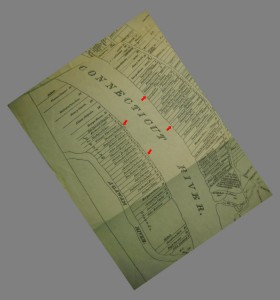
A 1640 hand-drawn map of land grants in Springfield, Massachusetts compares surprisingly well with a satellite view today.
Arrows point to Rowland Stebbins’ grants and those of his son Thomas.
Some observations:
- Note that Thomas Stebbins Born: 6 MAY 1662 married Elizabeth WRIGHT, daughter of Samuel WRIGHT and Elizabeth BURT.
- The Wrights and Burts were next door neighbors of the Stebbins slightly to the South. So it does appear that Thomas married, “the girl next door.”
- Margaret Street leads to… Margaret’s land grant. If related, this makes sense in 1640, but folks who see that street now would have no idea.


This is wonderful! Do you happen to have a good photo of the entire map or know where I can get one? My 8th great grandfather, James Taylor, was a Scottish prisoner of war from the battle of Dunbar in 1650. After surviving being marched to Durham Cathedral in England he was put on a ship to Boston and indentured at Saugus Ironworks. After his indenture was completed he was approached by John Pynchon to be indentured to him for one year in Springfield. He agreed and ended up becoming an esteemed member of the town. He was given a land grant by the town of Springfield on February 2, 1674. It was noted when his son was selling some of his land. I’d love to see if I might figure out where it would have been using some of the names in the description. Thanks in advance for any help.